
How Chicago gerrymanders local maps
From 'the lobster' to 'the pool noodle,' there’s no excuse for Chicago City Council’s tortured ward boundaries.


Gerrymandering is dominating the national political conversation.
Virginia voters last week narrowly approved a constitutional amendment allowing the state to redraw its political maps ahead of the 2026 midterms—joining a brushfire of mid-decade gerrymandering sparked in Texas.
But mapmaking isn’t just a game for congressional districts. Chicago local government uses cartoonish cartography, too. And unlike the craze of partisan gerrymandering sweeping states across the nation, there is no “tit-for-tat” excuse for Chicago’s system.
It is simply voter suppression. And there’s a straightforward fix to stop it.
Chicago’s gerrymandered ward maps
The waterslide. The pool noodle. The barbell. The seesaw. These are a few of the terms used to describe the boundaries of Chicago’s 36th Ward.
An equally apt descriptor: the punishment.
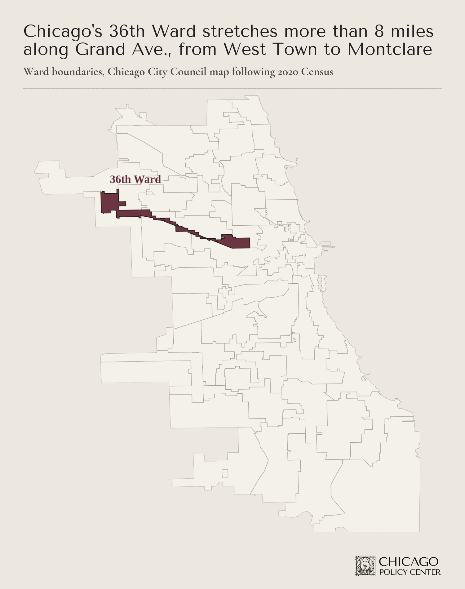
Incumbent 36th Ward Ald. Gil Villegas led Latino Caucus opposition to the ward maps following the 2020 census. Consequently, his home ended up 8 miles away from some of his new constituents.
At least his home was still in the ward. The most gerrymandered ward in Chicago following the 2010 Census was the 2nd Ward. Dubbed the “lobster,” its bizarre shape was owed in part to drawing the incumbent’s residence out of the ward entirely.
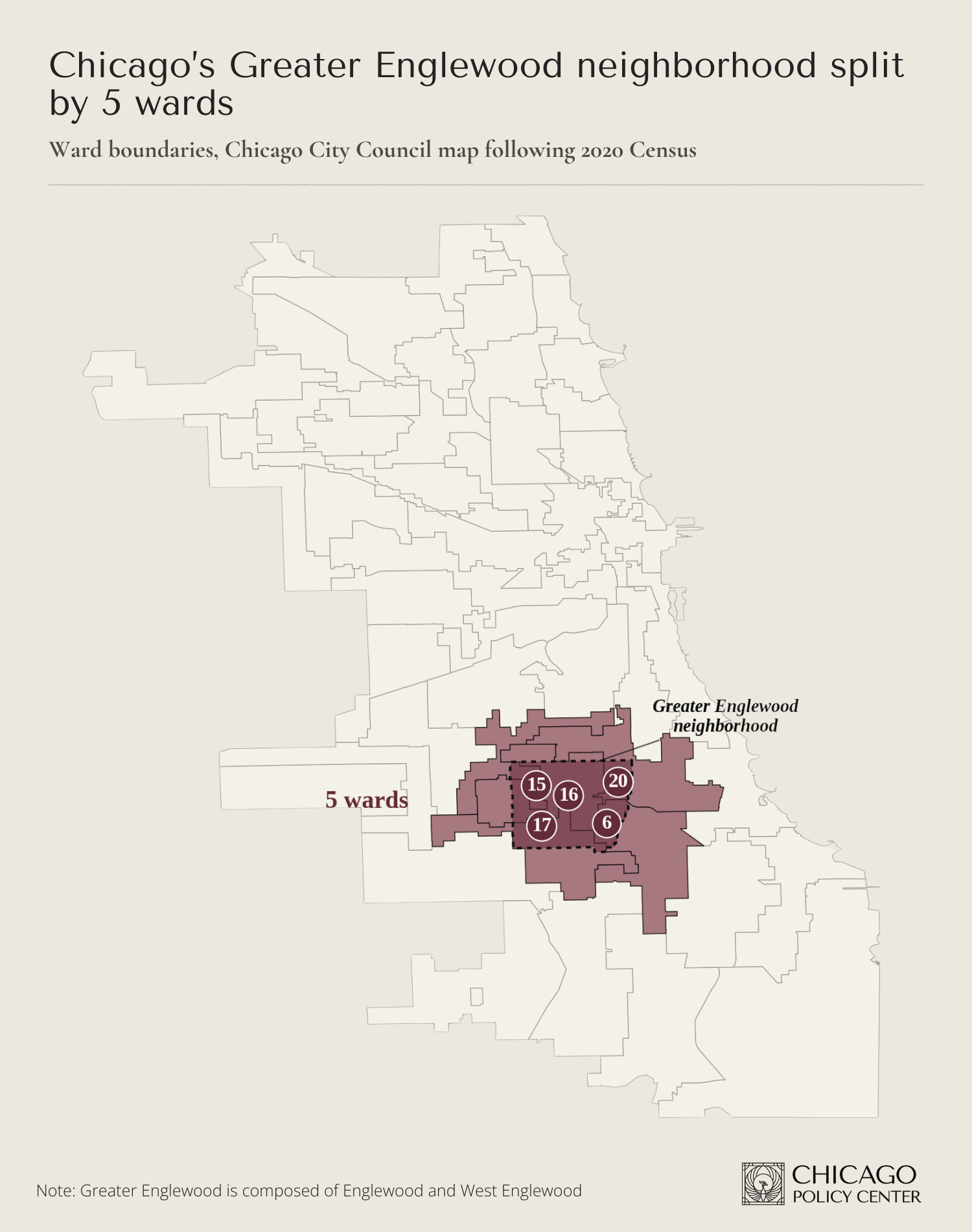
The petty political dramas that play out in mapmaking create problems for neighborhoods like Englewood, which is sliced up across five wards. One longtime resident summed up the political dynamic: “too many cooks in the kitchen.”
All of this happens because under Chicago’s current mapmaking system, politicians pick their voters.
How Chicago politicians pick their voters
State law requires Chicago to redraw its ward boundaries after each federal census. Those wards must have roughly equal numbers of residents.
If City Council can’t agree on a map by the deadline, any group of 10 aldermen can put a map to voters via referendum. This has only happened once in the city’s modern history. In 1992, Chicago voters approved a map drawn by the Daley administration and aldermanic allies. (For context: The political fight following the 1990 census was so contentious that Ald. Dorothy Tillman allegedly pulled a gun at a community meeting on the topic.)
In practice, this system means City Council whips 41 votes every decade to pass a new map. Members trade favors behind closed doors in a “map room” at City Hall, drawing boundaries block-by-block, often in concert with the sitting mayor.
How other big cities draw council maps
The sordid details of big-city political mapmaking are typically hidden from the public.
But in Los Angeles, those details leaked. In 2022, a secret recording surfaced that contained a conversation between three City Council members about gerrymandering, laced with racist insults, recorded at a local union headquarters.
In the wake of that scandal, council members passed an amendment to the LA city charter creating an independent mapmaking commission for the 15 city council districts. Voters approved that charter amendment overwhelmingly.
In New York City, the process for local mapmaking is still vulnerable to political meddling. But the city charter does prevent monstrosities like Chicago’s 36th Ward, mandating that a district “shall be no more than twice as long as it is wide.”
Chicago has no city charter to govern basic governance matters, like how to draw its City Council maps. Getting one requires a change to state law.
Short of that, voters should demand candidates for office in the February 2027 municipal elections support creating an independent citizens commission to redraw the maps following the 2030 census.1
In the news
Last week I joined ABC7, Fox32, and WGN Radio to discuss the “millionaires tax” constitutional amendment highlighted in last week’s edition of The Last Ward.
The constitutional amendment failed to secure enough Democratic votes to pass the full House last week. It will not appear on the November ballot.
For an example of what an independently drawn ward map might look like in Chicago, check out the People’s Map.